
This article follows on from the Nature v Nurture one. It involves the concept of rewilding and especially the rewilding of HGC. If you’ve read the previous article you’ll know that Bill Longbone and myself were congratulated by a young man on our efforts to tidy the cemetery of litter. He then said he supported rewilding of the HGC and then left us, leaving us both somewhat bemused. Were we doing that?
Neither of us were 100% certain that picking up the detritus of others was actually ‘rewilding’ except in its loosest sense. We both shrugged and carried on.
I’m also very sorry that this article is a bit technical and bolstered by footnotes and cited evidence. Unfortunately evidence must be used here as without it people make ludicrous claims without the slightest shred of evidence. For example ‘rewilding’.
History is bunk
I was thinking about the idea of the rewilding of HGC much later. Quite some time after I had met this young man. I thought how far fetched the concept of doing such a thing to the HGC site was. And this is where the historical aspect that I mentioned in the previous article comes to the fore.
I suppose I should say here what my problem with his statement was. I’m pretty sure that the young man’s idea of ‘rewilding’ went something like this. HGC is a cemetery but has been allowed to become a woodland. This should be encouraged by more trees being allowed to grow. If more trees grow the site becomes ‘wilder’ and therefore it encourages more wildlife.
Simple isn’t it?
Its a nice simple plan. I think I’ve addressed the problems you can have with simple plans in the previous article but I’m pretty sure that was the sum of his idea about ‘rewilding’ of HGC. So foresting is the way to go. The more trees grown on the site will return the site to its pristine state before it became a cemetery. Great, let’s do it.
Well, its not quite that simple. Let’s have a closer look.
I’m pretty sure that most people who read stuff on this site have an interest in history. That interest may be small or large depending on the individual but it will be there. So what I’m going to say may be well known to some but not to others. For you antiquarian experts please be patient and let others catch up.
Fresh water
The history of Hull was shaped by many factors. Not least of them was the search for fresh water. Charles 1st laid siege to Hull in 1642 at the beginning of the Civil War. He thought that he could, if not starve the inhabitants into surrendering, he could bring them to heel by denying them fresh water. The vast majority of the fresh water that was drunk in Hull at that time came from Anlaby. Charles, in throwing a siege around the town, deliberately interrupted that source. We’ll discuss how this source came about later.
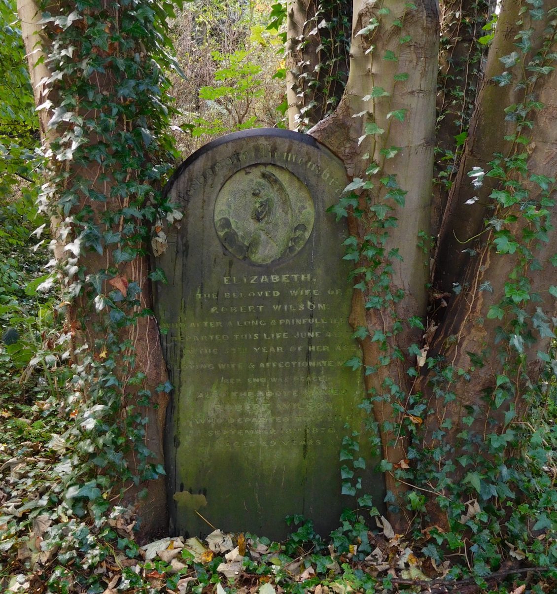
Charles, unfortunately for him, was told that his plan was stupid. Probably not as bluntly as that but just as clearly. Ex-Governor of Hull, Sir Thomas Glenham, said that the people of Hull need only dig down a little way for the hole to fill with fresh water. A little brackish, yes, but still drinkable. Charles was also told that at low tide the River Hull was a fresh water source and all the people needed to do was dip their buckets in it. Indeed Glenham went on to say that, ‘they cannot bury a corpse there but the grave drowns him ere it buries him.’ (1) A feature I know too well from past experience.
So, when it came to emergencies, like being under siege, the citizens of Hull could get by on the fresh(ish) water on site. However, when the choice was between fresh spring water and the brackish water, well, that was a different matter entirely.
Water courses
Wyke, later to become Kingston upon Hull, had a fresh water source about two miles to the west. This was at Springhead, known then as Julian Wells. This spring, followed a natural path to the emerging town. This water course was first recorded in 1293, some six years before the town of Hull was graced with attention from Edward 1st.(2) The spring was said to follow a circuitous course eventually reaching the town at what is now the end of Whitefriargate.
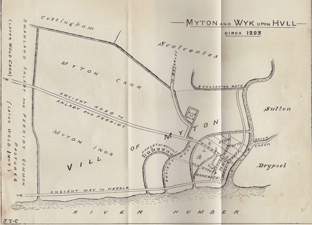
As can be seen from the above sketch map, made by Hull historian J. Travis-Cook in 1903, the ditch ranges from the top left of the map until eventually emptying into the ancient moat.
Eventually, after many tribulations, the course of this spring was fixed in 1401 and a ditch was dug to a depth of five feet, five feet wide at its bottom and twelve feet wide at the top.(3)
Julian Dyke
This water course, known as the Julian Dyke, later Derringham Dyke, and later still Spring Ditch, emerged at Springhead. It then followed the course of the present day Spring Bank West, Spring Bank and Prospect Street. The dyke eventually flowed into a basin called the Bush Dyke. This was approximately where Prince’s Dock and the old Queen’s Dock would have met. This was the first primitive reservoir for the town and Bush-Dyke men went around the town selling fresh water from barrels that they carried.
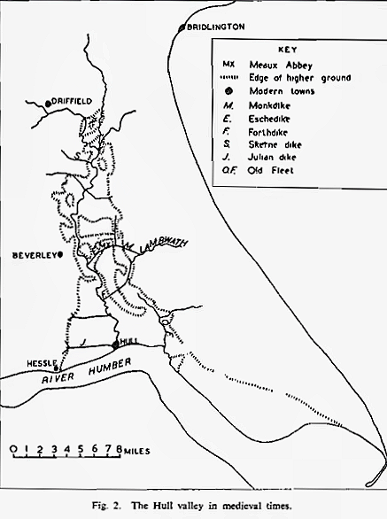
Of interest in the above map, taken from Sheppard’s ‘The Draining of the Hull Valley’, is the line of higher ground. Cottingham, along the line of Castle Hill to Keldgate was probably the nearest high ground above the flooding of the River Humber. In fact, if you bother to stop at Keldgate today and look south, you can see the entire southern Hull valley, now occupied by a large city. A thousand years ago it would have been a marshland with reeds and the odd misshapen tree as the tallest structures in it.
Farming
So, why am I telling you all this in the context of rewilding?
Because of a very simple reason. The presence of managed water courses, and the Julian Dyke was managed very thoroughly and efficiently by the Court of Sewers, suggests, that the land on either side of it was constantly being drained. In a predominantly wet landscape, a drained portion of land would not have been left long before humanity took advantage of it.
Farming would have been the role for the land that eventually became Hull General Cemetery, from the medieval period, up to 1846. Prior to its change to farmland it would have been marshland, used for pasturing in summer, and fishing and trapping in the winter. Due to its nature its highly unlikely that there were many trees in it. The consensus of opinion is that, after the last ice age, trees were initially abundant, but by 1000 BCE the forest coverage had been much reduced. This reduction has continued up to the present day.(4)
Evidence
The evidence all suggests that the site of the present HGC was firstly marshland up until it was drained sometime in the 13th and 14th century. After that it was farmland. It continued to be farmland until taken over by the Hull General Cemetery Company in 1846. It was at that time that forest trees were planted on the site. These were probably the first on the site since before Roman times.
The Company planted a lot of trees and shrubs. After it’s downfall those trees and shrubs best suited to proliferate without maintenance began to predominate. Thus we have the site as it is today. An urban woodland. That’s good.
Finally
Yes, I can hear your sigh of relief from here.
What the present state of the HGC is not is a return to how it ever was. Especially in the idealised past that the term ‘rewilding’ used here conjures up. It’s present state is not some happy chance that has returned it to its roots (pun intended). It is man-made.
If we want a true rewilding of HGC then we should destroy the site’s drainage system. The Company dug this system 14 foot beneath the site’s surface back in 1846. We should destroy the woodland. We should eradicate the present woodland wildlife. After that we can re-wild the site back to its marshy status. Imagine the clumps of solid earth infrequently poking above a wet landscape populated by wading birds.
Lots of luck with that. If you don’t mind I’ll sit this one out thanks.
Notes
1 p.2, Mary Fowler, “River and Spring“, 1997
2. p.42, E.Aylwin & R.C.Ward, “Development and Utilisation of Water Supplies in the East Riding of Yorkshire.“, 1969
3. p.42-3, Edward Gillett & Kenneth A. MacMahon, “A History of Hull“, 1980. If you’d like to know all about the ‘tribulations’ mentioned above, one of which included the Pope becoming involved, may I recommend the three books cited and also “The Victoria History of the County of York, East Riding, Volume 1“, Ed. K.J.Allison, “Hull; Culture, History, Place“, Eds. Starkey, Atkinson, McDonough, McKeon & Salter, “Yorkshire from AD1000“, D. Hey, “General and Concise History and Description of the Town and Port of Kingston-Upon-Hull“, J.J.Sheahan, “ Becks, Banks, Drains and Brains“, The River Hull Valley Drainage Heritage Group, 2013 and of course the wonderful EYLHS booklets by June Sheppard, “The Draining of the Marshlands of South Holderness and the Vale of York” & “The Draining of the Hull Valley“. 1966 and 1958 respectively.
4. Numerous sources. pp-6-7, Eva Crackles, “The Flora of the East Riding“, 1990 states that the forest coverage was at its maximum ‘some 7000 to 5000 years ago’.
The River Hull Drainage Heritage Group, already cited, states on p.8, ‘This meant that spring fed right bank tributaries originating on the Chalk Wolds to the west of the pre-glacial cliff line all flowed out across low-lying carrs and ings to reach the River Hull (….) This landscape chaos was what the Norman conquerors beheld as they secured their conquest in the 11th century A.D. This was a tract of land to skirt, unless your business was wild-fowling or fishing.’
J.R. Flenley in ‘Vegetational History’ in “Humber Perspectives: A Region Through the Ages“, 1990, states that around 1000 BCE, Elms began to decrease, possibly due to a variant of the recent Dutch Elm Disease but more probably due to humanity chopping the young growth to feed livestock. He also states that, in the iron age, with the stronger plough, ‘The resulting clearance of forest in Holderness is beautifully demonstrated by the Roos Pollen count again suggesting mixed farming’.p.51. There are other accounts to validate this evidence. In essence forest land in the Hull valley from, at the very latest, the Roman period, was quite rare.
Pete Lowden is a member of the Friends of Hull General Cemetery committee which is committed to reclaiming the cemetery and returning it back to a community resource.
Great article on re-wilding Pete, as you say, how far do you go back? Do we let all of the clay cliffs fall back into the sea because that’s how it was! The chalk wolds were by description formed in shallow lagoons in the sea.